Walking in the North Pennines
| Author | Paddy Dillon |
| Publisher | Cicerone Press |
| ISBN | ISBN-10: 1 85284 084 6 (First Edition)
ISBN-13: 987 1 85284 493 6 (Second Edition)
ISBN-13: 978 1 85284 905 4 (Third Edition)
Also available in eBook and Kindle formats |
| Price | £12.95 |
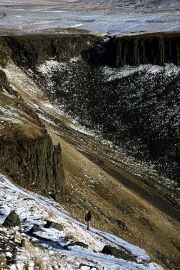
Snow on the colonnaded cliffs around High Cup, on the East Fellside flank of the North Pennines.

Low Force is one of a series of splendid waterfalls that can be seen in Upper Teesdale.
Dark clouds plunge Cross Fell into shadow in this view from the Vale of Eden.
The first guidebook in a long association with Cicerone Press. While writing a series of walking route descriptions for Country Walking magazine, it became apparent that there was no comprehensive walking guidebook covering the whole of the newly-established North Pennines AONB (now designated as a National Landscape).
A selection of articles covering a variety of walking routes around the North Pennines were sent to Cicerone with a proposal for a guidebook. After a brief discussion a contract was issued and the research began in earnest. The North Pennines are wild and remote, more so than any other part of England, and the high moorlands are wide-open to whatever the weather hurls at them. The first edition of the guidebook was researched in a series of visits spanning all four seasons.
For the second edition, the entire guidebook was completely overhauled. All the walking routes were checked again during a single long summertime trip, being completely re-written. New routes were added, bringing the total to 50. The new edition was in full colour, complete with all the routes highlighted on OS Landranger mapping.The book is now in its third edition.
Walk Contents
Section 1 - Geltsdale
| Walk 1 |
Brampton, Gelt and Talkin |
| Walk 2 |
Hallbankgate and Cold Fell |
| Walk 3 |
Castle Carrock & Geltsdale |
| Walk 4 |
Croglin, Newbiggin and Croglin Fell. |
Section 2 - East Fellside
| Walk 5 |
Hartside, Black Fell and Renwick |
| Walk 6 |
Melmerby and Knapside Hill |
| Walk 7 |
Maiden Way - Kirkland to Alston |
| Walk 8 |
Blencarn, Cross Fell and Kirkland |
| Walk 9 |
Knockergill Pass - Knock to Garrigill |
| Walk 10 |
Dufton, Great Rundale and High Cup
|
Section 3 - Warcop Range
| Walk 11 |
Murton, Murton Pike and Murton Fell |
| Walk 12 |
Hilton and Tinside Rigg |
| Walk 13 |
Mickle Fell via the Boundary Route
|
Section 4 - Stainmore
| Walk 14 |
North Stainmore and Slate Quarry Moss |
| Walk 15 |
Kirkby Stephen and Nine Standards |
| Walk 16 |
Tan Hill Inn and Sleightholme Moor |
| Walk 17 |
Bowes & Bowes Moor |
Section 5 - Lower Teesdale
| Walk 18 |
Greta Bridge and Brignall Banks |
| Walk 19 |
Barnard Castle and the Tees |
| Walk 20 |
Woodland and Copley |
| Walk 21 |
Cotherstone and Romaldkirk. |
Section 6 - Middle Teesdale
| Walk 22 |
Tees Railway Walk |
| Walk 23 |
Middleton and Monk's Moor |
| Walk 24 |
Middleton and Grassholme. |
Section 7 - Upper Teesdale
| Walk 25 |
Low Force and High Force |
| Walk 26 |
Holwick and Hagworm Hill |
| Walk 27 |
Cronkley Fell |
| Walk 28 |
Cow Green and Widdybank Fell |
| Walk 29 |
Cow Green and Herdship Fell. |
Section 8 - Weardale
| Walk 30 |
Wolsingham and Frosterley |
| Walk 31 |
Stanhope and Stanhope Dene |
| Walk 32 |
Westgate, Middlehope and Rookhope |
| Walk 33 |
Chapelfell Top and Noon Hill |
| Walk 34 |
Rookhope to Stanhope. |
Section 9 - Derwentside
| Walk 35 |
Waskerley Way - Parkhead to Consett |
| Walk 36 |
Edmundbyers and Edmundbyers Common |
| Walk 37 |
Blanchland and Blanchland Moor. |
Section 10 - Devil's Water
| Walk 38 |
Devil's Water and Hangman Hill |
| Walk 39 |
Dipton Mill and Dipton Burn. |
Section 11 - Allendale
| Walk 40 |
Allen Banks and Staward Gorge |
| Walk 41 |
Allendale Town and Hexhamshire Common |
| Walk 42 |
Allendale Town and Allenmill Flues |
| Walk 43 |
Ninebanks, Hard Rigg and the Dodd. |
Section 12 - South Tynedale
| Walk 44 |
Alston, Garrigill and River South Tyne |
| Walk 45 |
Alston, Lambley and Haltwhistle |
| Walk 46 |
Slaggyford and Grey Nag. |
Section 13 - The Dale-heads
| Walk 47 |
Allenheads and Killhope Law |
| Walk 48 |
Cowshill and Killhope |
| Walk 49 |
Killhope Cross and Knoutberry Hill |
| Walk 50 |
Nenthead and Nag's Head |