
Walking the Galloway Hills
| Author | Paddy Dillon |
| Publisher | Cicerone Press (out of print) |
| ISBN | ISBN-10: 1 85284 168 0
ISBN-13: 978 1 85284 168 3 |
| Price |
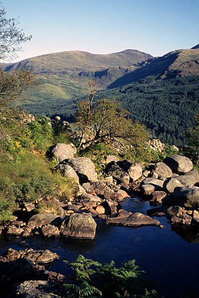
Looking from Buchan Burn towards the rugged hill of Curleywee.
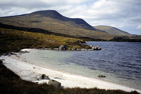
The Merrick, the highest of the Galloway Hills, seen from the shore of Loch Enoch.
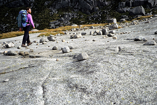
Paddy Dillon walking along the curious De’il’s Bowling Green in the heart of the Galloway Hills.
A casual suggestion from Cicerone led to a prolonged and strenuous exploration of the broad, bleak, boggy, rocky Galloway Hills in South West Scotland.
The route research was accomplished a bit at a time, a week here and there, stretching from winter into summer. Accommodation was usually in remote mountain bothies, or by establishing wild camps in the hills, while the walks were tackled day after day, sometimes without setting foot on tarmac for a week. A sudden fall of deep snow hampered the route research in the winter, while annoying plagues of midges made it difficult in the summer, but eventually it was all completed.
The routes venture deep into the Galloway Hills, where walkers often need to be self-sufficient, as well as being good navigators. The terrain is notoriously rugged, while the placenames of the region are amazing - Curleywee, Mullwharchar, Craigeazle, Shalloch on Minnoch, the Range of the Awful Hand, the Dungeon Hills, and many more.
Harvey Maps offered the use of their detailed Galloway Hills map when they heard about this project, so extracts from their map appear throughout the book. That contact led to another small project, as the Galloway Hills map needed a new Visitor Guide to be written and illustrated, for distribution with the map.
Although the guidebook is out of print, Cicerone have published another edition written and illustrated by Ronald Turnbull.
Walk Contents
| Walk 1 | Stroan Bridge Forest Trails |
| Walk 2 | Loch Trool Forest Trail |
| Walk 3 | Fell of Eschoncan and Pulnagashel |
| Walk 4 | Bennan and the Fell of Eschoncan |
| Walk 5 | Merrick and Loch Enoch |
| Walk 6 | Merrick and Kirriereoch Hill |
| Walk 7 | Tarfessock and Kirriereoch Hill |
| Walk 8 | Cornish Hill and Shalloch on Minnoch |
| Walk 9 | Carrick Forest Drive and Cornish Hill |
| Walk 10 | Loch Riecawr and Tunskeen Bothy |
| Walk 11 | Kirriereoch Hill from Tunskeen Bothy |
| Walk 12 | Mullwharchar from Tunskeen Bothy |
| Walk 13 | Macaterick from the Carrick Forest Drive |
| Walk 14 | Around Craigmawhannal from Loch Doon |
| Walk 15 | Mullwharchar from Loch Head |
| Walk 16 | Carlin's Cairn from Loch Head |
| Walk 17 | Carlin's Cairn and Corserine from Polmaddie |
| Walk 18 | Corserine from Backhill of Bush |
| Walk 19 | Milldown from Backhill of Bush |
| Walk 20 | Tops of Craigeazle from Backhill of Bush |
| Walk 21 | Darrou, Little Millyea and Meikle Millyea |
| Walk 22 | Darnaw and Court Knowe from Black Loch |
| Walk 23 | Cairnarroch and Millfore from Craigencallie |
| Walk 24 | Millfore from Auchinleck |
| Walk 25 | Lamachan Hill from Auchinleck |
| Walk 26 | Larg Hill from Caldons Campsite |
| Walk 27 | Lamachan Hill and Mulldonoch |
| Walk 28 | Curleywee and Lamachan Hill from White Laggan |
| Walk 29 | Craiglee and Loch Dee from White Laggan |
| Walk 30 | Craiglee from Craigencallie |
| Walk 31 | Loch Valley and Craiglee from Glen Trool |
| Walk 32 | The Dungeon Hills from Backhill of Bush |
| Walk 33 | The Dungeon Hills from Glen Trool |
| Walk 34 | The Forest Walk |
| Walk 35 | The Awful Hand Walk |
| Walk 36 | The Rhinns of Kells Walk |
| Walk 37 | The Minnigaff Hills Walk |
| Walk 38 | The Dungeon Hills Walk |
| Walk 39 | The Grand Tour |
| Walk 40 | The Southern Upland Way |